

Unha-3, Taep'o-dong -2
(TD-2) 3rd. Experimental Satellite Launch Flight Test Failure
The Sohae Satellite Launching Station in Cholsan County, North Phyongan Province, Pongdong-ni, or Dongchong-ri or Tongch'ang-dong West Coast Facilities (25)
6-4/10-26-2009/3-16-31 thru, 5-25-2012 11-01-12 /11-23-12
Rev.12
©By C. P. Vick, 2012
Senior Technical & Space Policy Analyst
Globalsecurity.org
Introduction
On April 13, 2012, North Korea time launched a Taepo-dong-2 missile. The missile was tracked on a southerly launch over the Yellow Sea. This open source analysis on the fourth satellite launch failure reviews the open source information to clarify what actually took place as opposed to numerous errors prone reports identified.
North Korea’s continued insistence that it is “their sovereign legitimate right to have an indigenous satellite launching as a part of their peaceful space program to demonstrate its economic, & technological power” is certainly important in understanding that this effort is driven by the need for hard foreign currency for the regimes survival. This raised the problem of its potential application as a Limited Range ICBM which the DPRK denies is its intent. Equally the fear is also what Iran has already gotten from North Korea‘s & what they may get in the future that drives the international concerns as written in the UNSC “resolutions” Number s, 1718, & 1874 etc., against such activities.
Taep'o-dong-2 class Flight Test Record
| Flight | Date | Success/Failure |
| 1. Flight Test (1) | 07-05-06 | Failure |
| 2. Flight Test (2) | 04-05-09 | Failure |
| 3. Flight Test (3) | 04-13-12 | Failure - Admitted by DPRK |

The North KoreanTaep-o-dong-2B/Unha-3 revised booster that sports a new liquid propellant third stage apparently derived from Unha-1 booster design.
Build Up to the Experimental Flight Test Reports
Static test firings of the engines have already been accomplished in [(October, 2010 on the Dong chang-ri static stand site of the new launch infrastructure (1)]….which is right on Time.” (2) “This comes from both US and South Korean personnel reflecting the FYP cycle (predictability whether understood or not).” (2) Regardless of press report suggestions to the contrary it can be stated that this was no hurry up launch decision that was over five years in the planning stages. Earlier reports from South Korean officials as reported by the Yonhap News Agency indicated that the Tong chang-dong northwestern second DPRK launch site was not completed as of February 16, 2011. (34)
[Also at that time in July 2011 it was reported that the Dong chang-ri launch facilities infrastructure was very nearly completed.] (3) Subsequently in July 2011 it was reported by The Chosun Ilbo, quoting South Korean government sources, that North Korea was laying railroad tracks between the Tongchang-ri railroad station and the launch infrastructure (4)
DPRK Announcement
As if on “Q” the DPRK main radio Station announced what had apparently been precisely timed for the present Five Year Plan actual schedule.
DPRK March 16, 2012 Announcement
“ Pyongyang, March 16–KCNA— DPRK to Launch Application Satellite , The DPRK is to launch a working satellite, Kwangmyongsong-3, (Bright Shining Star) manufactured by itself with indigenous technology to mark the 100th birth anniversary of President Kim II Sung.
A spokesman for the Korean Committee for Space Technology said this in a statement Friday.
After successfully launching two experimental satellites, DPRK scientists and technicians have steadily conducted scientific researches to develop and utilize working satellites indispensable for the country's economic development in line with the government's policy for space development and peaceful use.
Through the researches they have made a drastic progress in the field of space science and technology and laid solid material and technological foundations for working satellite launches and operation.
Kwangmyongsong-3, a polar-orbiting earth observation satellite, will be blasted off southward from the Sohae Satellite Launching Station in Cholsan County, North Phyongan Province between April 12 and 16, lifted by carrier rocket Unha-3 (Galaxy-3 ).
A safe flight orbit has been chosen so that carrier rocket debris to be generated during the flight would not have any impact on neighboring countries.
The DPRK will strictly abide by relevant international regulations and usage concerning the launch of scientific and technological satellites for peaceful purposes and ensure maximum transparency, thereby contributing to promoting international trust and cooperation in the field of space scientific researches and satellite launches.
The upcoming launch will greatly encourage the army and people of the DPRK in the building of a thriving nation and will offer an important occasion of putting the country's technology of space use for peaceful purposes on a higher stage."(5)
This included information for watch, warning reports provided by the DPRK to the International Civil Aviation Organization, the International Maritime Organization, the International Telecommunications Union and others as required by international law.
The data presently available seems to indicate first stage is to impact 170-140 km off the coast of Byeonsan, South Korea, south of its southwestern city of Gunsan, that is 20 km wide and 250 km long and second stage and shroud elements impact 190 km well east of the Luzon Island of the Philippines over the Philippines trench region impact zone of 160 km wide and some 800 km long all over international waters between 3,150-3,950 km from the launch site. Payload and third stage shrouds should impact about 3,200 km down range. The first stage is expected to separate at an altitude of 150 km with impact in the sea about 280-450-500 km from the launch pad site at 39.660107 N, 124.7053203 E .
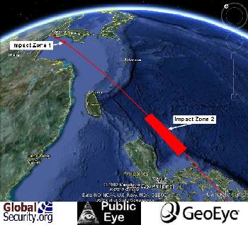
Illustrations of the flight plan as submitted by North Korea to the International Civil Aviation Organization, Globalsecurity.org Photo credit: Google Earth.
Credit: Tim Brown Senior Fellow Globalsecurity.org that developed the illustration and the referenced analysis
Based on the North Korean data supplied to the International Civil Aviation Organization, the International Maritime Organization, the International Telecommunications Union and others as required by international law the following information applies. (7, 8)
Launch of the Kwangmyongsong-3, a polar-orbiting earth observation satellite is to be launched
Time: 07:00 ~ 12:00 Daily Local Time. [2200-0300 GMT]
Place of launch: The West Sea Sohae Satellite Launching Station in Cholsan County, North Phyongan Province between April 12 and 16, 2012
Impact Zones:
First stage impact zone:
35 degrees 12’ 25” N 124 degrees 52’ 23” E
35 degrees 12’ 13” N 124 degrees 34’ 34” E
35 degrees 55’ 10” N 124 degrees 50’ 25” E
35 degrees 55’ 20” N 124 degrees 32’ 10” E
Second stage & Shrouds impact zone:
15 degrees 8’ 19” N 124 degrees 46’ 15” E
15 degrees 09’ 35” N 123 degrees 45’ 27” E
19 degrees 23” 08” N 124 degrees 45’ 13” E
19 degrees 24’ 32” N ` 123 degrees 54’ 26” E
Potential Mission Payloads Question Kwangmyongsong-3
North Korea can fly out of this Tongch'ang-dong facility to polar orbit inclined just west of a due south inclination for an imaging/ERTS/RECSAT or weather imaging satellite launch or for a limited range LRICBM test without going over other countries territory. While a near due east flight out of Musudan-ni would be for a communications satellite probably for store dump military communications traffic or could be for an LRICBM test flight. This is the fourth satellite launch attempt by the DPRK. In truth “Earth observation satellite” description can cover a multitude of mission including Earth resources, mapping imagery, reconnaissance photo imaging and or radar imaging operations as well as weather in low earth polar orbit. A polar orbit satellite is not an advanced geostationary meteorological satellite which is launched from an equatorial orbit not polar orbit . Kwangmyongsong-2 was an experimental communications satellite as was also Kwangmyongsong-1 according to the North Korean News Agency KCNA.
Satellite Details & Mission Data
On March 28, 2012, KCNA the official North Korean News Agency interviewed the vice director of the Space Development Department of the Korean Committee for Space Technology (KCST) answering the critical questions on the Earth observation satellites expected orbit, missions and payload mass. The two year useful life 100 kilogram satellite has multiple missions primarily built around ERTS earth resources satellite technology as well as the added benefit of meteorological weather forecasting. The rectangular box satellite sports four solar arrays of twin two panels for deployment with several external sensors one of which is a side looking instrument or camera on top and five antennas. (29) Close examination of the 1 meter tall satellite display revealed that there is only one fixed corner for the solar arrays with two hinges between the two panels on each side at the 90 degree point to fold around the satellite body. One hundred and eighty degrees from the solar arrays attachment point there are no attachments to hold the solar arrays around the body of the satellite except for launch. So the four solar panels to provide electrical power deploy from one corner creating a flat array away from the satellite body. The four sides of the satellite were obscured by the solar arrays with only the top and bottom visible. Whether this was the satellite flight article is questionable but it probably was a full working model utilized in ground testing.

The North KoreanSatellites/Unha-3 revised booster payload.
It is to be launched into a polar solar (Sun) synchronous orbit at 500km high altitude with an inclination of 97.40 degrees with an orbital period of 94.737 minutes. (9) However this may in fact be incorrect based on new analysis developed. (See below from Ted Molczan .) The DPRK is now emphasizing that it is a small earth observation polar orbiting satellite probably launched at 88.7 degrees inclination with a third stage limited performance plane change to 94.5 deg while close to a sun-synchronous launch would be at the previous indicated 97.40 degrees inclination which is believed to be outside the booster’s performance capability based on the launch corridor restraints.
Satellite data Transmission
The satellite will broad cast its data in the UHF, radio band while its video will be in the X-band according to the International Telecommunications Union. The UHF band utilizes frequencies in the 300MHz to 3 GHz range with several frequency ranges reserved for satellite use. The X-band covers frequencies in the 7GHz to 12 GHz range for satellites.
Report: Suggest the DPRK Satellite Mission is Not as Previously Portrayed
Reply:Ted Molczan: "RE: North Korea satellite: NOTAMs inconsistent with claimed sun-synchronous orbit"
http://satobs.org/seesat/Apr-2012/0011.html
North Korea satellite: NOTAMs inconsistent with claimed sun-synchronous orbit
From: Ted Molczan
Date: Mon Apr 02 2012 - 02:46:09 UTC
North Korea claims that its upcoming rocket launch will place a satellite in a 500 km, sun-synchronous orbit:
http://www.kcna.co.jp/item/2012/201203/news28/20120328-40ee.html
"It weighs 100kg and will circle along the solar synchronous orbit at 500km high altitude."
The sun-synchronous claim is inconsistent with the NOTAM coordinates North Korea has issued for the impact zone of the rocket's two stages:
NAVAREA NO.12-0174 Date:2012/03/19 12 UTC
YELLOW SEA AND NORTH PACIFIC, LUZON.
ACCORDING TO INFORMATION FROM NORTH
KOREA VIA IMO, ROCKET LAUNCHING.
IMPACT HOUR 2200Z TO 0300Z COMMENCING
DAILY 11 TO 15 APR.
IMPACT AREAS BOUNDED BY
A. 35-12-25N 124-52-23E
35-12-13N 124-30-34E
35-55-20N 124-32-10E
35-55-10N 124-50-25E.
B. 15-08-19N 124-46-15E
15-09-35N 123-45-27E
19-24-32N 123-54-26E
19-23-08N 124-45-13E.
CANCEL THIS MSG 150400Z APR.
Stage 1 would impact in zone A; stage 2 in zone B.
The launch site is located at 39.660107 N, 124.705203 E.
To be sun-synchronous, a 500 km orbit requires an inclination of 97.42 deg. At the latitude of the launch site, a trajectory that directly ascends to that inclination requires a launch azimuth of approximately 192.3 deg (12.3 deg west of due south). The azimuth from the launch site through the various impact zones downrange should agree closely with this value, typically within a degree or so, absent any significant yaw-steering (aka dogleg) early in the ascent.
The azimuth from the launch site to the midpoint of the southern boundary of the 2nd stage's impact zone (approx. 15.15 N, 124.26 E) is 181.0 deg, which is far from the required 192.3 deg.
I considered the possibility of an eastward dogleg early in the ascent, but the trajectory would have to turn toward approximately 192 deg azimuth well before the 2nd stage ceased firing, in which case the 2nd stage's impact zone should be oriented with its east and west sides pointing roughly toward azimuth 191 deg, but they do not. The west side points toward azimuth 181.8 deg, and the east side 179.8 deg - again far from the required value, and essentially identical to the azimuth calculated from the launch site. Therefore, there is no dogleg, which is not surprising, since it would involve over flying the Korean peninsula, probably including South Korea.
I do not see how North Korea could reach a sun-synchronous orbit from the new launch site without risk to populated areas. Launching directly toward the required 192.3 deg azimuth would result in a trajectory that skirts China's east coast near Shanghai. The rocket's second stage would over fly Taiwan, before impacting in a zone bordering within perhaps 50 km of the west coast of the northern Philippines.
To give a *very rough* idea of the effect of launching directly toward azimuth 192.3 deg, I have adjusted the longitudes of North Korea's NOTAMs:
A. 35-12-25N 123-42E
35-12-13N 123-20E
35-55-20N 123-33E
35-55-10N 123-51E
B. 15-08-19N 119-38E
15-09-35N 118-56E
19-24-32N 119-43E
19-23-08N 120-34E
I very much doubt that North Korea plans for its rocket stages to fall in the zones I have estimated, but it is for North Korea to explain the inconsistency between the orbit it claims to be targeting and the NOTAMs it provided.
Ted Molczan (10)
______________________________________________
Seesat-l mailing list
http://mailman.satobs.org/mailman/listinfo/seesat-l
The NOTAMs are consistent with an 88.7 deg inclination, which is nowhere near sun-synchronous.
As I discussed in my analysis, for the 2nd stage impact to occur as given in the NOTAMs, would require an eastward dogleg early in the ascent, overflying the Korean peninsula, probably including S. Korea. I can tell they are not planning to do that, because if they were, then the 2nd stage impact NOTAM coordinates would be pointing toward approx. azimuth 191 deg, instead of the actual ~181 deg. Of course, it is highly unlikely they would perform such a dogleg, because it would create a huge international incident to cross S. Korea.
My analysis shows that without an eastward dogleg, they would have to follow a trajectory that skirts China's east coast near Shanghai, and the 2nd stage would pass over Taiwan and impact close to the west coast of the northern Philippines. I provide the approximate 2nd stage NOTAMs for that scenario, but I do not believe that is what they intend.
Had they claimed the orbit was near-polar, without adding the sun-synchronous claim, then the NOTAMs would be consistent. Given North Korea's historical lack of credibility, and considering that the sun-synchronous claim was attributed by KCNA to "a vice director of the Space Development Department of the Korean Committee for Space Technology (KCST)", I believe that the most reasonable interpretation is that they are lying about this being a satellite launch, which has been betrayed by the incompetence of their propagandists in over-reaching in their cover story. (11)
Sun-synchronous orbits generally are preferred for both earth-resources and IMINT satellites. An 88.7 deg orbit would be considered a poor choice for such missions. An ordinary polar launch (near 90 deg) cannot be narrowed down to any specific type of mission. But North Korea has claimed an ERTS type mission in sun-synchronous orbit, so they must be held to that claim and required to account for its inconsistency with the NOTAMs, because both cannot be true. Orbits between roughly 85 deg and 90 deg are seldom used for RECSAT or ERTS. They are not strongly associated with any particular type of mission, but have been used for various types of scientific research, communications (e.g. Iridium), navigation (e.g. Transit) and SIGINT. (12)
North Korea satellite: retrograde ground track displayed in launch control centre
From: Ted Molczan Date: Wed Apr 11 2012 - 01:36:53 UTC
Included in some of the video shot by journalists covering North Korea's upcoming rocket launch, are launch control display screens depicting a southbound ground track that to the eye looks close to that of a sun-synchronous satellite orbit. It has been discussed on the NSF and NK forums. I have been working to estimate the orbit implied by the ground track and to evaluate its consistency with the location of the launch site, NOTAMs, and other information issued by North Korea.
The first images I saw had insufficient resolution or coverage to confidently estimate the orbit. Fortunately, late last night Charles Vick informed me of the following video, which is the clearest I have seen yet:
http://www.youtube.com/v/GpjGwG414rY&hl=en_US&feature=player_embedded&version=3
The relevant scene appears for several seconds beginning at 01:56 elapsed time.
Notice that the track begins on the other side of the Earth, rises above the northern limb, then proceeds south over China, the Korean peninsula and so on. The track appears to be a 3D representation of the initial orbit around the Earth.
Based on a notional launch on 2012 Apr 12 at 02:30 UTC, and assuming a 500 km circular orbit, I estimate that the orbit is inclined approximately 94.5 deg:
1 79802U 12103.11415511 .00000000 00000-0 00000-0 0 05
2 79802 94.4500 182.0500 0002000 359.9726 179.8827 15.21000000 00
I estimated the inclination and RAAN by trial and error fit to a couple of reasonably clear land marks visible on the display. Since the orbit has been plotted as a 3D representation, there is potential for parallax error in the ground track, but it is mitigated by the more or less perpendicular vantage point. I estimate the RAAN and inclination are accurate to within several tenths of a degree.
The epoch is of no special significance; it and the mean anomaly have been chosen to place the orbit near the launch site about 4 min after lift-off, which is a useful rule of thumb to estimate the location of a newly launched satellite within its orbit.
I was especially interested to determine whether the 94.5 deg orbit intersects with the 88.7 deg inclined ascent trajectory, and whether the location is plausible for the 3rd stage firing. Here is a plot of both trajectories:
http://satobs.org/seesat_ref/misc/NK-2012-retrograde-1a.jpg
Here is a view near the ascent trajectory:
http://satobs.org/seesat_ref/misc/NK-2012-retrograde-2a.jpg
The point of intersection is near 28.25 N, 124.5 E, about 1270 km downrange of the launch site, which seems to be in rough agreement with the plot of altitude vs. range in this recent analysis by David Wright (see Fig.2):
http://allthingsnuclear.org/post/20730991602/a-comparison-of-north-koreas-unha-2-and-unha-3
The orbit is not sun-synchronous, but better than the 88.7 deg orbit implied by the NOTAMs, for the stated purpose of the satellite. Sun-synch orbits precess +0.9856 deg/d. The 88.7 deg orbit would precess -0.1730 deg/d; the 94.5 deg orbit +0.5917 deg/d.
To be precisely sun-synch, a 500 km orbit must be inclined 97.4 deg. The apparent nearly 3 deg deficit may be an indication of the performance limitation of the launcher. I do not exclude the possibility that the displayed track was faked to mislead the news media, but it should not have been more difficult to produce a high-fidelity fake, assuming the work was done by the trajectory specialists. Considering the relative position of the numerals 4 and 7 on a keypad, a simple, honest typo also cannot be excluded.
Ted Molczan
_______________________________________________
Seesat-l mailing list
http://mailman.satobs.org/mailman/listinfo/seesat-l
March 24, 2012-Satellite Booster arrival On the Launch Infrastructure
The Unha-3 booster first two stages “Main Body” in addition to other elements of the satellite launch vehicles individual stages arrived on it transport erectors inside the Dongchang-ri , Sohae Satellite Launching Station in Cholsan County, North Phyongan Province. It was delivered by “specially equipped train” to the onsite MIK horizontal assembly check out building on Saturday March 24, 2012 via the newly completed railroad infrastructure from the north Pyongyang, Sanum-dong Missile Development Center factory according to South Korean & U. S. military officials. The information was provided by the South Korean defense ministry and it’s Joint Chiefs of Staff on Sunday, March 25, 2012 via South Korean & U. S. Military intelligence sources without attribution. (16)
It is now understood that two full Unha rockets were taken from the north Pyongyang, Sanum-dong Missile Development Center factory to the Sohae Satellite Launching Station in Cholsan County, North Phyongan Province according to South Korean, government officials. (69) No doubt this provided a backup identical booster incase that was required that has also allowed for simulation testing to define the reasons for this failed launch.
North Pyongyang, Sanum-dong Missile Development Center Factory Infrastructure
The north Pyongyang, Sanum-dong Missile Development Center factory constitutes a vast facility, testing grounds and general R&D, production conglomerate as modern as and facilities in the high technology Western world. This is the result of studying the Google Earth images publically available on line. It contains wind tunnels that are near identical to the most advanced US, NASA and USAF facilities. In deed the infrastructure is like combining the NASA Marshall Spaceflight Center, Langley Research center, Glenn Research Center and Ames Research Center, in addition to the Tullahoma, Arnold Air Force Base facilities with it Arnold Engineering Development Center. In some cases it reminds one of facilities that only the US has and they are near identical to the US designs. How they have achieved this is indeed an intriguing question with many implications.
Yes this infrastructure contains the General satellite Command & Control center. It also apparently handles much of the military aircraft development for the DPRK. The facility also utilizes other static test firing and dynamic test facilities located on the Musudan-ri,” ( Tonghae Satellite Launching Ground infrastructure in Hwadae County , in North Hamgyong Province) as well as the Pongdong-ni, or Dongchong-ri or Tongch'ang-dong, Sohae Satellite Launching Station in Cholsan County, North Phyongan Province infrastructure. This is beyond the Pyongyang surrounding general Space Program and Military Ballistic Missile R&D infrastructure all working under the same DPRK Government employer roof serving both so called civil and military requirements. The Pyongyang region also includes the Earth Station with its large Dishes and the General Satellite Monitoring Facilities with it multiple smaller dishes.
Imagery Reports
The March 20, 2012 GeoEye commercial imagery first images report was released on this web site revealing very little activity in major infrastructure facilities prior to launch vehicle arrival. See: http://sitrep.globalsecurity.org/articles/120322840-new-imagery-shows-north-korean.htm
The March 28, 2012 DigitalGlobe commercial imagery revealed that contrary to reports out of Japan there was no booster on the pad at that time though the infrastructure activity had indeed commenced as evident in the increased vehicles traffic present . (56) Follow up survey suggested that all the propellant tanker trucks had arrived and may have finished their initial delivery to the launch pad infrastructure semi underground storage sites behind the gantry umbilical tower. Among those were about 16 tankers at one parking clean out site while a second clean out parking site has about 8 tankers. There is in fact a third semi-underground propellant storage facility along with the fourth facility for high pressure gases converter facility for such gases as Nitrogen and or Helium all installed all along the same pad circling road behind the gantry umbilical tower. Several mobile telemetry and radar dish’s vanes were also identified on the launch infrastructure similar to previous identified operation.
The additions of a mobile radar and telemetry receiving equipped van were also identified at the end of a newly developed unfinished road. This is typical of previous test launches of the Unha-2 booster launch preparation.
Propellants
The first stage propellant are strongly believed to be based on Scud-B propellant as noted from Soviet manuals which is TM-185 20% Gasoline, 80% Kerosene while its oxidizer is believed to be AK-27I 27% N2O4 + 73% HNO3 with Iodium inhibitor Nitrogen Tetroxide & Nitric Acid.
SEE: http://www.globalsecurity.org/wmd/world/dprk/td-2-specs.htm and http://www.globalsecurity.org/wmd/world/dprk/nd-a-propellants.htm
The second stage Propellant is known from Soviet Naval references manuals to be Unsymmetrical Dimethylhydrazine (UDMH) while its oxidizer is known to be a derivation of Inhibited Red Fuming nitric Acid (IRFNA), ( 73% Inhibited Red Fuming nitric Acid (IRFNA) & 27% N204 = AK-27S) in the second and third stages..
The third stage uses the same propellants as the second stage with a liquid storable propellant attitude control unit with post boost maneuvering capability for satellite deployment.
Third Stage Design Change out to Liquid Iranian Derived Stage Design
The 30 meter long & 2.5 meters in diameter, 91 metric tonnes launch vehicle with 120 tonnes thrust Unha-2, 3/TD-2 booster’s, third stage is an Iranian derived liquid stage of the Safir program but much more sophisticated in this rendition difference from the failed solid motor design of the 2006 and 2009 launch. (27) (29) The third stage was lengthened from the solid motor based 3 meter stage to the liquid stage length of about 0.8 meters.

The North KoreanTaep-o-dong-2B/Unha-3 revised booster that sports a new liquid propellant third stage apparently derived from Unha-1 booster design and No-dong-B vernier propulsion engine.
The March 31, 2012 GeoEye commercial Imagery still shows no launch vehicle on the pad but the gantry tarps curtains appear to be in the process of being added from the top down to the ground to the service levels for environmental control.
The April 1-8, 2012 commercia imagery is not available for unknown reasons with one known to have been withdrawn but is presumed to shows no clear view of a booster on the pad as suggested by Chosun Ilbo from information obtained from South Korean government sources. (17). However the gantry umbilical tower curtains tarps installation is also presumed to have been completed from the ground to the top of the service levels. The DPRK booster installation on the launch pad was expected to occur during the period April 5, through April 7, 2012 based on Soviet class operation practices analysis. The possibility of the booster first three stages being on the pad is considered possible but not proven. The encapsulated satellite and then the third stage shrouds should have been installed but that remains uncertain on this writing (17)
Whether the erector transporter was used in this particular case to assemble the completed booster on the pad remains unknown and unproven at this reading. South Korea officials in the Chosun Ilbo article suggested that it was to be lifted by the gantry umbilical tower crane stacking one stage at a time on the rail mobile multi-sized adapter launch platform but again it was definitely fully assembled on the pad by the end of Friday or on Saturday. (32) April 7 th. , if not earlier according to South Korean officials exactly as expected. (17)
The April 8, 2012 - Sunday Imagery “Ground Truth ” came from the onsite DPRK invited foreign space analyst specialist and journalists guest of the international press of over 70 reporters, cameramen and photographers. They were required to be there on Sunday morning April 12, 2012 for the unprecedented launch site tour. They included reporters from the AP, Reuters, AFP, CNN, NBC, BBC, Swiss TV, Le Monde, Vietnamese TV, Phoenix TV, Channel News Asia, Indonesia TV One, South African’s ETV, Brazil’s Estado de Soa Paulo, Kyodo News, NHK, Zvezda, NTV, Russia Channel One, German’s RARD, Sweden’s STV, Inhaul, Xinhua, and Sky News, with two space specialist James Oberg of NBC and Christian Lardier of Air & Cosmos as guest of the DPRK. They are to be followed by other that at the time were still in transit to view the April 15, 2012 military parade in Pyongyang. Most of the journalist and specialists arrived on Friday and Saturday DPRK time in spite of the U.S. Department of State asking the world press and specialist not to give support to the DPRK “peaceful space launch,” geo-political legitimizing, physiological warfare efforts. They had to take a five hour train ride of 115 kilometers to the launch infrastructure from Pyongyang. (28) Literally the gantry umbilical tower curtain tarps encasing the service levels disappeared from the service levels before April 7 was over from the March 31-April 5 installation and use before removal. They would reappear on the top service levels to encapsulate the satellite installation area temporarily after the press unveiling visit.
Post Sunday April 8 th - April 9, 2012 Activity to follow. The DPRK official Mr. Jang Myong Jin at the launch site acknowledged that in the following days fueling of the “ 30 meter tall 2.5 (2.48?) meter diameter, 91 metric tonnes with 120 tonnes lift-off thrust Unha-3 carrier rocket ” (29, 41) three stage space booster would be carried out then it would be followed with the installation of the 100 Kg small applications technology polar orbiting earth observation imaging satellite for weather and earth natural resources. This was from the General Manager of the satellite launch infrastructure Mr. Jang Myong Jin. He also emphasized that “ this launch had been in the planning for a long time….” and that “ The rocket is equipped with a self–destruct system…,” and that it can be destroyed remotely by ground controllers and that the vehicle also has a sensing instrumentation system on board to destroy itself if it starts to deviate from the planned programmed trajectory. (29) The small mass of the satellites that was expected to be placed in a near polar orbit of 500 kilometers is due both to the orbital altitude required and the booster’s third stage inclination plane change from 88.7 degrees to 94.5 degrees short of 97.4 degree to be sun-synchronous.
Additionally Mr. Jang Myong Jin noted that the DPRK plans to launch a 400 metric tonnes booster in the future . (29) This has to be the 40 meter long missile sighted at the north Pyongyang, Sanum-dong Missile Development Center factory in US intelligence imagery. (22) In relation to this experimental satellite launch attempt he emphasized that “… the relatively diminutive rocket and fixed (soft site) Sohae station would be useless for sending a mobile ICBM”(41), “ To say this is a missile test is really nonsense” & “ It is a carrier rocket but not a ballistic missile.” (31, 40) “ If it were ballistic missile it would have to be hidden in an underground chamber, or would need to be carried on board another vehicle for protection. If it were not, then it would be useless in a real war,” (29) It was also stated that “ North Korea has concrete plans for further satellite launches from Musudan-ri,” ( Tonghae Satellite Launching Ground (infrastructure) in Hwadae County , in North Hamgyong Province ) as well as the Sohae Satellite Launching Station in Cholsan County, North Phyongan Province within the existing five year plan. (33)
April 8, 2012 Sunday - International EROS-B Commercial Imagery This imagery for now has settled the suggestion by this analyst of the use of a transporter erector when it revealed the transporters tractor trailers for the first and second stages as well as the third stage transporter believed to be on site but not identified. This means as the South Korean’s officials suggested that the booster is assembled stage by stage by using the gantry crane to stack the stages and encapsulated payload over a day’s time. This was the on-site press tour day.
April 9, 2012 Monday - Digital Globe, Inc., Commercial Imagery This Image gave more credence to the previous day’s imagery that the boosterwas delivered to the launch site by strong back tractor trailer dollies carried on railroad flat cars covered with green tarps and plastic wrapping to protect it from unnecessary contamination. It clarified the pre-entrance encapsulation cleaning room before introduction to the main assembly hall operations of the MIK horizontal assembly building prior to shipping to the launch pad for final assembly and flight preparation operations. Equally it reinforces the notion of a soft vulnerable launch site space booster operation and not a threatening strategic nuclear weapons carrying ballistic missile operation. Chosun Ilbo noted on April 9, 2012 that according to South Korean sources that the “North Korea appears to have completed assembling the second and third stages of the rocket at the launch pad on Saturday after setting up the first stage on Friday”, they also suggested that the satellite had already been installed and that the 1--3 day propellant loading operation had started. (42) This was in spite of Mr. Jang Myong Jin the General Manager of the satellite launch infrastructure stating that fueling would take place before the satellites installation on the launch vehicle as previously noted. This ultimately turned out to be the reverse of what was done.
April 10, 2012 Tuesday – Ryu Gum Chol, the Deputy Director of the Space Exploration in the Department of Space Technology in the DPRK of the Committee for Space Technology while briefing the international press on April 10, 2012 at the Pyongyang General Satellite Space Command & Control Center, stated that “We are expecting all the assembly and preparation of the satellite launch are to be done by the end of the day”. He also stated that the “Kwangmyongsong-3 satellite…was being mounted on the third stage”, before the end of the day to finish out the preparation and that only the automated propellant loading of the launch vehicle was left to be done according to Ryu Gum Chol. (43, 44) Before that installation and shroud encapsulation operations was started the gantry umbilical tower curtain tarps encasing the top of the launch vehicle reappear on the top service levels to encapsulate the satellite installation area temporarily. (49)
Equally Ryu Gum Chol reiterated the message to the world that the DPRK wanted to convey when he stated, “No country in the world would want to launch a ballistic missile from an open site” dismissing the assertion that the space launch was a cover for a missile test as “nonsense.”(43)
April 11, 2012 Wednesday – This day was in part occupied with the automated propellant loading injection operations of the launch vehicle’s three stages after the completion of the assembly operations according to Ryu Gum Chol. (43, 44, 46) Paek Change Ho the director of the General Satellite Space Command & Control Center for the Committee for Space Technology stated that “We are injecting fuel as we speak.” & “And as for the exact timing of the launch, it will be decided by my superiors.” (48)
Once the propellants which are storable highly toxic very volatile and corrosive with inhibitors are loaded on board the booster the launch has about five to seven day before the launch vehicle tanks and engines would have to be drained and cleaned out and get recoated with inhibitor back at the factory.
This was probably followed by an electronic countdown demonstration to clear the booster for the flight countdown. Dependence on the weather conditions both at the launch site and at altitude was the governor for when the launch attempt would take place.
April 12, 2012 Thursday – The launch was waved off for the April 12, 2012 apparently due to the expected weather overcast conditions. (47) Flight launch countdown begun aimed at a Friday morning launch as planned. At some point an over 30 minute delay in the launch was apparently carried out for some unknown but circumstantial reason. South Korean and Japanese officials stated that there was no evidence Thursday morning to suggest that the launch was about to take place. (45)
April 13, 2012 Friday –Background Discussion
This analyst is not as confident of the open source information available on this launch failure both because much of it is undocumented and not consistent. The failure to get the Air Force Bulletins and other radar data with timing altitude information on the failures and parts separation looms large in the unknowns. There are issues with who is using the launch start at 7:39:00 AM or at 7:38:55AM Korean standard time creating more confusing errors in the event timing issues.
Here it must be remembered that North Korea said that the “The rocket is equipped with a self–destruct system…,” and that it can be destroyed remotely by ground controllers and that the vehicle also has a sensing instrumentation system on board to destroy itself if it starts to deviate from the planned programmed trajectory. (29) We must also note if the third stage with its satellite payload and fairing's with its primary guidance package for the overall booster is decapitated from the main over all booster the process of destroying the booster may be interrupted or precluded. What makes sense from the two different scenarios descriptions and what are the obvious errors?
Scenarios on the Failure
Those conflicting scenarios center around whether the first stage impacted first or continues on its normal operation though cut off on the planned programmed trajectory and whether the second stage separated properly or remained attached to the first stage. The first scenario reports came from the combined US, South Korean and Japanese on site intelligence personnel joint efforts while the second scenario came out of the northern command and its space assets. Both scenarios have their logic processes that reflect the intelligence processes utilized. However the second scenario does not stand up well under the open source information available to the contrary. Which one is correct is anybody’s guess.
Typically the intelligence process for events is scheduled for debriefs as the events take place, 5 to 15 minutes after the event then 30 minutes afterwards to 45 minutes and 1 hour then 2 hours, then 4 hours and so on for longer intervals’ through the following days as the data is collected and analyzed. That is followed by a combined agencies intelligence conference thrashing out the issues that have arisen from the individual analysis but it is now foreshortened with inter-intelligence cooperation sharing to get it right much earlier. That process appears to have been initially completed by April 15, 2012.
Logic tells us that what explodes first will land in the first impact zone while what rises to the highest altitude and also fails will impact in the last impact zone furthest down range. If the first stage continues it burn to completion flying to its proper ballistic altitude then something else had to have taken place for the earlier series of explosive failures. Were there two impact zones or only one impact zone? So how does this work out and is there Western intelligence deception to misguide the DPRK to what is really known or uncertain at that time? Yes, something is obviously amiss here.
The Open Source Evidence
South Korea’s King Sejong, Aegis–class destroyers’ equipped with 1,000 km radar’s, did not detect the launch until 45 seconds after liftoff at [7:39:00/ 7:38:55 A. M.] and (7:39:49 A.M.(53)). (51, 53) Both Japanese and South Korean Aegis–class destroyers’ were not in the most optimal positions to observe the launch failure as they were deployed at the best positions to intercept the flight if that need had arisen.
“The Japanese, the chief of staff of Maritime Self-Defense Force (Japan Navy) Sugimoto Masahiko said "The fact is our Aegis ships could not detect the rocket". He said radars of three Aegis ships deployed at the East China Sea and the Sea of Japan could not detect those. They were so far away from the impact point of the rocket because they were located on the points suited to intercept the rocket. Two Aegis ships seemed to be located in near Okinawa and another one ship in the Sea of Japan. The ship on the Sea of Japan was unnecessary and should have located it in the northern part of the East China Sea. Japan was not able to record the track of the rocket at all, except the radar of the antisubmarine patrol aircraft.” (52) In affect the Japanese data came from the combined efforts. This would imply only South Korean & U.S., Land, Sea & Space assets were close enough to gather that critical data on the early part of the flight.
The North American Aerospace Defense Command (NORAD) and the U. S. North Command officially acknowledged that the “U.S. system detected and tracked a launch of a North Korean Teapo-dong-2 missile at 6:39 P.M. EDT.” It further stated that” The missile tracked on a southerly launch over the Yellow Sea, according to a statement released by Peterson Air Force Base in Colorado.” It went on to say “ initial indications are that the missile’s first stage fell into the sea 102.5 (statute) miles (164.9225 kilometers [165 kilometers]) west of Seoul, South Korea” and that, “The other two stages were assessed to have failed and no debris fell on land. …”(54)
In reality it was west of Pyeongtaek, south west of Seoul, South Korea. This suggest that “the first stage successfully separated” from the launch vehicle before completing its burn. (50) That in and of its self is in fact questionable based on open source information as shall be shown or is it the reverse? Eventually either range control destruction more probable than anything else or aerodynamics would have broken the stages apart as they overheated on their ballistic reentry.
Errors Identified?
The “102.5 miles” (164.9225 kilometers or 165 kilometers) has to be wrong as it should have been a little over or less than 200 kilometers (124.28 miles) or it was way off the launch inclination of 88.7 degrees location bringing into question the accuracy of the statement in addition to other data that follows . Saying the first impact zone was west of Seoul, South Korea when it was Pyeongtaek, south west of Seoul, South Korea, just added to the confusion.

The North KoreanTaep-o-dong-2B/Unha-3 flight profile showing the NORAD error.
When OSD was questioned on this both the OSD and NORTHCOM had “…nothing to add to the original statement.” So we are left with a potential mystery.
The suggested 100-150 kilometers from the port city of Gunsan impact zone was also later proven to be wrong. (53) The suggestion of the flight time of 47 minutes and 42 seconds was also wrong because it was on the order of 4 minutes and 42-45 seconds in reality for the first impact zone. The premature propellant loading report out of Japan was also wrong since no vehicle was on the pad. (56, 53)
*Apparently the South Korean Ministry of Defense gave out much more information during a press briefing on April 13, 2012 that is apparently undocumented and unavailable that was not completely reported in the open press.* (70)
Open Source Evidence Continued
The DPRK stated “ Pyongyang, April 13, (KCNA) -- The DPRK launched its first applications satellite Kwangmyongsong-3 at the Sohae Satellite Launching Station in Cholsan County, North Phyongan Province at 07:38:55 A. M. on Friday. The earth observation satellites failed to enter its preset orbit scientists, technicians and experts are now looking into the cause of the failure.” (55)
“The South Korean defense ministry said the rocket exploded within one or two minutes after lift-off and separated into around 20 pieces. Whether the first-stage separated from the rest of the rocket was still under investigation, it said.” (53)
“The North’s Unha-3 rocket disappeared from the radar around 7:43 A. M. into the Yellow Sea of South Korea, Just a few minutes after its launch, the official confirmed.” and “It remains unclear whether the second stage of the three-stage rocket had separated, the official said, citing (South Korea’s joint Chiefs of staff in Seoul said, South Korean & U. S. intelligence) he gathered from Seoul’s defense minister.” It was said to have been launched at 7:39 A.M. (57)
“The Unha-3 rocket exploded in just one or two minutes after lift-off at 7:39 A. M. and disintegrated into about 20 pieces and crashed into international waters off South Korea West coast, according to South Korea’s Defense Ministry.” citing (South Korea’s joint Chiefs of staff in Seoul said, (South Korean & U. S. intelligence)) (58)
“We have confirmed that a certain flying object has been launched and fell after flying for just over a minute,” Japanese, Defense Minister Naoki Tanaka said…..” (62)
Japan’s Chief cabinet Secretary Osama Fujimura said “that an American satellite had detected a launch at (7:40) but the rocket remained in the air for slightly more than a minute then fell into the ocean.” COMPOSITE QUOTE of several news organizations (63)
“Military sources said the rocket appears to have landed in waters about 190-200 kilometers off South Korea’s western port city of Gunsan, without the separation of its first and second stages.” And “Japan’s NHK reported the North’s rocket ascended about 400,000 feet (120 kilometers rounded off) above ground before being separated into four pieces and then crashing. The report cited a Japanese defense ministry official.” (59)
“The Unha-3 rocket took off from the Dongchang-ri launch site at 7:39 A. M. but burst into pieces after flying about one or two minutes, Shin won-shik, a senior (South Korean) Defense Ministry official, said during the briefing.” And “After reaching a final altitude of 151 kilometers, the rocket exploded (135 seconds) and began falling in about 20 pieces, Shin said. The Debris landing over a broad area in waters about 100-150 kilometers off South Korea’s west coast.” (60)
Apparently the South Korean, Ministry of Defense gave out much more information during a press briefing that is apparently undocumented that was not reported in the open press.* (70) Within that briefing it was stated that “…the explosion came 135 seconds after lift-off.” That is as the booster lost momentum going off the flight plan. (70) There were also South Korean Air Force Bulletins and RG, ground radar data reports. The initial flare up at 81-90 seconds observed by U. S. infrared satellites sensors after launch apparently at an altitude of 393,720 feet (or 400,000 feet rounded off) or “120 kilometers” as reported. (59, 71) Yet it continued to rise to 151.4 kilometers but was destroyed at 135 seconds into the flight. The broad area was 190-200 kilometers from Pyeongtaek, south west of Seoul, South Korea not 100-150. By static radar projection may have been at play in this apparent radar error. This was quite prominent in the 2009 launch failure thanks to the DPRK.
Thus who is right here or who do you believe because the 100-150 kilometers was previously stated to be 190-200 kilometers which makes sense to inclination or was it converted to NORTHCOM statement to be consistent? (59) Something is way off course and inconsistent. How many times did DPRK space agency personnel have to send the order to destroy the booster in flight? The final explosion as it headed ballistic-ally down range was almost certainly on board systems or ground ordered destruction on the booster in flight thus the 15-16 pieces identified. Oh whose clock does one use?
At “ 81 seconds ..” (50) “A different U. S. official told Security Clearance that the rocket failure happened 81 seconds into the flight, based on preliminary U. S analysis.” Quoting Barbara Star, CNN Pentagon Correspondent. (50)
The altitude flare like failure if it was a failure at all was easily visible from the launch station’s grounds. In all probability 81 - 90 seconds is where the third stage may have come into play if that happened at all if the third stage and its possible explosive destruction occurred though the first stage continues its burn. If the first stage continued its burn as it apparently did it is unlikely that the third stage was destroyed primarily because it would be needed to destroy the booster in flight as it apparently later on accomplish. Also if the second or third stage prematurely started up it would have destroyed the rocket stage below like other historic Soviet era missile failures have shown. I see no evidence that any telemetry was lost until its destruction probably by the on board sensors or ground controllers. The 81 - 90 seconds is decidedly well after max-Q had taken place and could have been a combination of the APU start up on the second or third stage as well as the attitude control systems start up activation and many antenna covers being jettisoned. It had initially broken into two pieces then four or five pieces before the final destruction creating the rest of the debris. Yes its first stage could have had its engines shut down early but that seems improbable. The booster stages burns appear to be Soviet styled “on” then “off” Cycle-gram operated propulsion. That is to be expected since most of the launch vehicles of the DPRK rely on the Soviet era Makeyev OKB, SLBM design heritage.
“According to U. S. defense officials, the rocket flared brightly and apparently exploded about 90 seconds into flight.” (61), (50)
All ballistic analysis indicates the booster first stage should have achieved an altitude of 150 kilometers or more if it did its full burn traveling about 410-470-500 plus kilometers down range . (70) With the mass of the forward second and third stages still attached the first stage was unable to achieve its maximum altitude expected. In reality the flare up apparently had no impact on the booster continued powered ascent on the planned flight trajectory. There is no doubt that the second stage failed to start properly after the first stage burn. Whether it successfully separated is an open issue among several on this writing.
The booster flight lasted on the order of 4 minutes or 4 minutes 42 seconds/4 minutes 45 seconds total depending on whose clock is used from lift off at 7:38:55 A.M. to Yellow Sea impact at 7:43:00 A.M. when it disappeared from the radar for the first impact zone reaching a maximum altitude of 151 kilometers over Baengnyeong/paengnyong Island DPRK before descending. It flaring going up and exploding in flight coming down.
According to Chosun Ilbo quoting South Korean, government sources suggested that the rocket launch failed initially “….. exploded 55 seconds earlier than initially reported, namely two minutes and 15 seconds after launch.” And that "There was a strange occurrence that looked like an explosion at 50 km above sea level around one minute and 20 seconds after the launch. The rocket continued to fly thanks to thrust and inertia, and at two minutes and 15 seconds, at 70.5 km above sea level, it split in two." (79)
There were a total of 20 pieces of detected debris caught on radar images of the flight performance. Initial impact 165 kilometers west of Pyeongtaek, south west of Seoul, South Korea in an area about 20 kilometers long from the out bound ascending explosion debris constituting 4-5 pieces of major debris. (64)
It had initially broken into two pieces then four or five pieces and later about 20 pieces in total. But that should have been a little over 200 kilometers from Seoul, South Korea to match the inclination unless something is widely amiss here due to the NORTHCOM statements or the missile was that far off course which seems improbable. That could means at least that part of the booster was off course.
The real question is did the range control of the DPRK actually attempt to destroy the booster in flight once or twice as it started to fail? Did the second or third stage startup prematurely in flight or failed to start properly. Was the two piece shroud fairing and or payload lost at Max-Q in the area of maximum dynamic pressure as it went supersonic or afterwards? Was the remaining booster destroyed by range safety after the second stage failure to start properly therefore severing the stages into 15-16 pieces
In any case the rest of the debris splashed down in international waters of which are slightly off course to inclination for the failed launch off the west coast of South Korea about 190-200 kilometers from the port city of Gunsan with the final 15-16 pieces of debris where the waters of the Yellow Sea are about 40-70-100 meters deep.
Friday the 13 th, Experimental Launch Failure Event Sequence:
This analyst is not as confident of the open source information available on this launch failure both because much of it is undocumented and not consistent. The failure to get the Air Force bulletins and other radar data with timing and altitude information on the parts separation looms large in the unknowns. There are issues with who is using the launch start at 7:39:00 A.M. or at 7:38:55A.M. helping to creating more confusing errors in the event timing. It had a daily launch window from 7:00 A.M., to Noon over the several days of April 12-16, 2012.
Event Timing Sequence:
1. Lift-off --------------------------------------------------------------7:38:55
--------------------------------------------------------------------------7:39:00 acquired launch
2. Max-Q--------------------------------------------------------------7:39:15
3. South --------------------------------------------------------------7:39:45 ship board
Korean Radar ------------------------------------------------------7:39:49 land based
Acquired launch
4. NORAD -----------------------------------------------------------7:40:00 acquired launch
5. NORAD----------------------------------------------------------- 7:39:36 – 7:39:81 2 parts then became 5 parts separated total
Flare Period --------------------------------------------------------7:39:45 -- 7:39:90 (50 Kilometers altitude 7:40:15, at 1 minute 20 seconds (80 seconds) after liftoff (79)) also stated to be 80-81-90 seconds in flight
6. First stage------------------------------------------------------- 7:40:15 – 7:41:00 Separation first and second stages did not occur
Shutdown
7. In flight 7:40:15 - 7:40:30 – 7:41:15, 2 minutes 15 seconds (135 seconds) after launch, Intentional destruction 15-16 pieces of debris at 70.5 kilometers (79) as it continued to fly ballistic-ally upward 120 km altitudes causing the debris to fall short of the planned down range first stage impact zone at 400 or so kilometers from the Sohae Satellite Launching Station
8. Max altitude. 151.4 kilometers for destroyed remaining booster stages (72)
9. Continued reentry breakup of the remaining 15-16 pieces identified. The Unha-3 flight time from lift-off around 7:39:00/7:38:55 AM to Yellow Sea impact at 7:43:00 AM or about 4 minutes/4 minutes 42/45 seconds after launch when it disappeared from the radar for the first impact zone. The stage elements as they went through the downward ballistic re-entry would have been over heated so that at about 100,000 feet and as they went supersonic probable disintegrated into many small pieces.
10. The second impact zone was around 9 minutes 30 seconds after launch. (72)
The DPRK Unha-3 met catastrophic disassembly after lift-off of Unha-3 occurred atm 55-60 – 81/90 – 112/118 /120 – 135 - 142.5 seconds into the flight in the area of maximum dynamic pressure as it went supersonic and beyond that altitude while still flying upward. In general in flight booster failures start earlier than they manifest themselves which appears later in flight .
The 81 - 90 seconds flare up is decidedly well after max-Q had taken place and could have been a combination of the APU start up on the second or third stage as well as the attitude control systems start up activation and many antenna covers being jettisoned. It had initially broken into two pieces then four or five pieces before the final destruction creating the rest of the debris but it had no effect on the powered ascent.
The two piece shroud fairing and the four pedals of the satellites solar array could easily account for the 2-5 pieces of debris initially spotted that dropped into the first impact zone 200 kilometers or so from Pyeongtaek, south west of Seoul, South Korea but that is speculation. Whether the third stage separated explosively from the booster stack is equally uncertain.
I cannot get around the nagging feeling that at some point around Max-Q that the fairing shroud may have partially let go and in part collapsed on to the satellite but did not let go. It would have been shook loose about 80 seconds into the flight as the antenna covers on the top of the third stage just below the shrouds base were jettisoned. Following at the 90 seconds point of the flight with the one side attached solar panels being ripped from the satellite body one attachment corner. That damaged the satellite but did not destroy it over and above the suggested a combination of the APU start up on the second or third stage as well as the attitude control systems start up activation. However this thought is unproven speculation without more information.
The first stage either completed it burn for on the order of 112-118-120 seconds before automatic cut off as planned that is reasonably certain since it flew to its proper ballistic altitude for its existing booster configuration. The booster’s first and second stages continued fly together ballistic-ally upward. The Unha-3 second stage did not start up properly and seems to have failed to separate properly at the right altitude.
Only after the second stage failed to start and separate did the booster lose momentum and thus both the on board system and ground controllers of the range would have ordered its destruction creating the remaining 15-16 pieces of debris that crashed 190-200 kilometers off the coast from Gunsan, South Korea. Yes at that destruction point the first and second stages did separate as they exploded.
*One is left wondering if the max-Q vibration frequency of the third stage was different from the rest of the booster structural frequency. Thus under maximum dynamic stress might have caused the shroud to fail and damage or destroy the satellite as well as exposing certain in flight antenna's. That in turn could have precipated a premature start of the second stage engines that failed to continue. Thus causing it to not start up when it should near the end of the first stage burn? It would appear that the DPRK engineering managers were some what concerned over this issue but went forward in spite of this potential hazard to their loss and quick identification of the failure mode of operation.
Guidance System PerformedThe guidance system performed from liftoff was much better than that seen with the 1998 Taep'o-dong-1 first satellite launch attempt. Taep'o-dong-1 flew near vertically before angling over and moving down rang but this Taep'o-dong-2 almost immediately curved over heading down range as a satellite launch should carry out in a very smooth flight pattern. It was even possible to see it correct its direction of flight as it moved down range soon after launch.
Launch Timing Question
It had a daily launch window from 7:00 A.M., to Noon over the four days. To suggest a launch within two weeks of arrival on site as recently suggested is highly improbable. Based on past practices it is more likely to entail 50-55 days or on the order of less than 10 days to in the horizontal assembly building to prepare the three stage booster and payload assembly before sending it to the pad horizontally for assembly on the pad for 8-10 days build up prior to launch. This is based on the 50 day or more horizontal assembly building build up process previously observed that was followed by the 20 and later on 10-12 days on the pad lead up to launch. Today they are calling for a launch to orbit between April 12-16, 2012 or all done in less than 20 days as compared to past practices observed. This clearly means this system has been in the planning preparation stage since the middle of the last five year plan of the DPRK. The expectations suggest for roll out that they are attempting to perfect an almost Soviet styled launch preparation operation. That implies that the vehicle will not go to the pad until 5-7 days prior to launch. The gantry crane can lift all the stages onto the pad to stack the booster and payload.
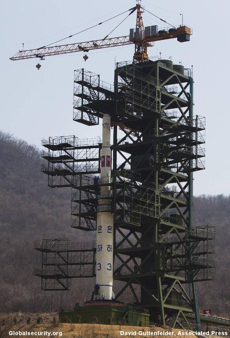
Globalsecurity.org Photo credit: David Guttenfelder, Associated Press.
Weather in the Launch Zone:
Predicted Weather conditions in the Sohae Satellite Launching Station in Cholsan County, North Phyongan Province between April 12 and 16, indicate that the weather may not be cooperating for the upcoming launch plans. Though the weather appears over cast for Thursday the 12 th., causing the launch to be waved off for later on in the week long launch window. The 13 th. , 14 th., of April it seems to indicate early fogg in the morning with partly cloudy conditions but it becomes mostly cloudy on the 15 th., but the 16 th of April appears to be partly cloudy.
Tracking, Range & Intelligence Observation Information Collection Efforts
Based on what North Korea has already given notice of it can be expected to clear required areas in the Yellow Sea through March 11-17, 2012 suggest that the launch from the West coast facility Tongchang-ri is going to fly out over the Yellow Sea in a near due south direction towards the equator not over South Korea and is as stated designed to place a satellite in near polar orbit that would be placed in orbit before flying over the Philippine region. The second stage impact zone is in the south Philippine Sea near Indonesia (New Guinea) near the Philippine Trench. Longer range flights could be flown out of the Tangch’ang-dong facility flying over South Korea to impact west of Australia 6,700 kilometers down range. The probability of the North Koreans flying out over North Korea or South Korean mainland I submit is highly improbable because of internal impact or avoidance of failure disaster issues much less threat issues confirming the polar orbit intent stated by the DPRK. To launch a satellite would be valid but an LRICBM would in part invalidate their clam of a space program for this booster proving the obvious dual purpose of the flights leading to external export to Iran for hard currency.
All previous international observation information gathering assets of South Korea and Japan in addition to the US are expected to commit to the data collection surveillance efforts. The two South Korean King Sejong and Yulgok Yi 7,600–ton, Aegis class Aegis–class destroyers’ equipped with 1,000 km radar’s, three Japanese Kongo Class Aegis–class destroyer’s equipped radar’s in addition to land based radars and SIGINT operations are to be part of the effort. Multiple US surveillance means such as land and sea based SIGINT and radar surveillance ships and crewed aircraft, stealth UAV’s in addition to sonar equipped ships of the various navy’s are certainly expected to be a part of the combined efforts. Down range ship based and land based surveillance efforts are to be assumed as also being a part of the regional effort. This like in 2006 and 2009 is to acquire the maximum independently crosses checked duplicative radar data as well as DPRK infrastructure operational data as is possible to correctly define the space booster’s systems performance or lack of performance as the case has been in the previous two experimental launch attempts. (18, 19)
Unfortunately in this case “The Japanese, the chief of staff of Maritime Self-Defense Force (Japan Navy) Sugimoto Masahiko said "The fact is our Aegis ships could not detect the rocket". He said radars of three Aegis ships deployed at the East China Sea and the Sea of Japan could not detect those. They were so far away from the impact point of the rocket because they were located on the points suited to intercept the rocket. Two Aegis ships seemed to be located in near Okinawa and another one ship in the Sea of Japan. The ship on the Sea of Japan was unnecessary and should have located it in the northern part of the East China Sea. Japan was not able to record the track of the rocket at all, except the radar of the antisubmarine patrol aircraft.” (52) In affect the Japanese data came from the combined efforts.
This would imply only South Korean & U.S., Land, Sea & Space assets were close enough to gather that critical data on the early part of the flight.
The US has put its Pacific Ocean deployed mobile oil–rig floating platform sea based large advanced 2,000 km range X-Band Radar-1 out of the Pearl Harbor home port on March 23, 2012 in preparation for monitoring the next TD-2 launch attempt. The U. S. Seventh Fleet has also committed five or six class Aegis destroyers along the launch corridor. Japan is putting its Maritime Self Defense Forces, Aegis class destroyer’s in the East China Sea also called the western Yellow-Sea near South Korea to monitor the Unha-3 launch for anti-ballistic missile defense but especially as a part of the U. S., South Korean and Japanese data gathering radar network and SIGINT electronic monitoring operations. Unfortunately the Japanese were deployed in a defensive configuration for this launch as previously noted.
The entire region around South Korea and Japan down through the Philippine region, western Pacific launch corridor is to have sea-based, land and space based systems sensors electronic monitoring of the entire flight for the maximum amount of duplicative data and provide for missile defense requirements if required. Besides the sea based Aegis class ships of the U.S., Japan and South Korea there are also land based SIGINT station in both Japan and South Korea as well as ground based radars and space tracking gear being prepared for this monitoring operation. All monitored data is being coordinated between the three nations and their deployed assets but especially for national security intelligence analysis. (18, 19) This effort did openly show real ranging errors that possible were precipitated by DPRK bi-static induced radar errors later corrected after the event by intelligence analyst. Those errors did manage to be released in the initial public official statements.
There is little doubt that DoD has imaged the launch pad activities regardless of weather, conditions, night or day on the round the clock operational basis by various means such as imaging stealth UAVs and stealth radar imaging UAVs.
Iranian Participants Observers:
Iranian participant, observers from the Shahid Hemmat Industries Group (SHIG), the Iranian liquid propellant launch vehicle design bureau organization, arrived March 31, 1012 in Pyongyang, DPRK. There were a total of 12 officials in the delegation of observer’s from Iran according to diplomatic sources with access to the information acquired. (65)
It reflects the latest ongoing commercial strategic cooperative programs relationship between the DPRK and Iran on missile and nuclear systems technology exchange. The launch failure is not merely a setback for the DPRK it is also a loss for the Iranian developing efforts impacting the overall cooperative technology exchange that may have ended up being the critical technology that caused the failure of this launch.
Booster Recovery Efforts after the Failed Launch Attempt
The waters off the South Korean coast have a depth of about 40 – 70 - 100 meters (72, 78) making it possible for South Korea to recover from the murky waters with strong currents, mudflats ocean floor bed the surviving broken up elements of the Unha-2, 3 booster’s first stage and perhaps the other elements of the second and third stage with its guidance package, and the payload, & shrouds. (39) That precise impact region will be defined by the two South Korean Aegis–class destroyer’s radar’s and or the US surveillance means such as surveillance ships and aircraft in addition to sonar equipped ships of both navy’s. (6) At least that is what was supposed to have happened which may now have shifter to undersea efforts.
On April 15, 2012, Yonhap News Agency reported that for three straight days the South Korea’s navies flotilla of about 10 ships including the “Cheonghaejin a submarine rescue ship and the four minesweepers as well as the P-C3 Orion anti-submarine aircraft” had “…..made little progress in recovering North Korean rocket debris…” while searching the impact zones in international waters on the Yellow Sea. (37, 78) This was primarily an ocean surface debris search that ran into a lot of floating and sea bed trash in the regions. No other nation’s foreign ships besides South Korean and U. S. vessels such as those of North Korea were observed in the region. (37) The other China and Russia vessels that patrol the region on April 13, 2012 had left the region. (78) According to the Korea Joongang daily on April 16, 2012 the international waters debris field was believed to lay in an area “(100 kilometers (39)) - 150 kilometers (actually approximately 200 kilometers) off the coast between Pyeungteak and Gunsan”. (38, 39) By April 17, 2012 the South Korean navy surface debris search was called off at 5:00 PM local time. (39, 78) That signaled the start of the planned undersea search efforts looking for the guidance and propulsion systems for retrieval.
Part of this long term effort is that the possibility of ocean surface debris was low and the issue of precisely locating the impact points would require US radar, sonar and undersea retrieval capabilities and South Korean mine sweeper sonar pattern searches followed by unmanned sea diving submersible with TV cameras video capability. Considerations of using a trawler was reviewed by South Korea officials but with no success and the sea bed trash situation revealed proved very frustrating. Note as indicated in this analysis the search could have been diverted from the right impact points because of the actual confusion over those impact points and the effect of DPRK radar bi-static projection of the flight path as well as unknown strong tidal currents. It may also require the US to refine the actual impact point relative to the space based asset’s identification information to share in this joint retrieval effort better carried out in obscurity without the press digging into it. It would also require a more complete understand of the launch failure details not yet fully analyzed that will continue in intelligence circles for months.
DPRK Space Effort to Continue: Additional Launches to Follow during this Five Year State Plan
Future space launches with in this state Five Year Plan will probably be delayed 12-18-36 months due to the April 13, 2012 launch failure. This has not daunted the DPRK State planning as is below emphasized. One could also expect more developments under the large 40 meter long dedicated geostationary space booster’s development program, large new growth potential launch pad gantry umbilical tower infrastructure (73) in addition the Unha series and the strategic No-dong-B and KN-08, LRICBM programs with in this Five Year Plan. This will over and above the three times a year regular missile testing training program operations.(20, 21, 22, 23)
The General Manager of the satellite launch infrastructure Mr. Jang Myong Jin stated that “ North Korea has concrete plans for further satellite launches from Musudan-ri,” within the existing five year State plan. (33) Later on after this set back from this launch failure it stated that it would “….continue to launch satellites for peaceful purposes will be put into space one after another” according to the DPRK Committee for Space Technology (KCST) as quoted from the Korean Central News Agency. (66, 67)
The Korean Central News Agency quote from the DPRK Committee for Space Technology (KCST) on April 15, 2012 as stating that “Scientists and technicians of the DPRK have already wound up the specific and scientific probe into the cause of Kwangmyongsong-3’s failure to enter its orbit.” And “All the scientific and technological data and previous experience gained this time will serve as a very precious boon to space development and a reliable guarantee for greater success in the days ahead.” It went on further to state “We have a comprehensive state plan for space development including expansion and strengthen of space development institutions as required by latest science and technology and continued launch of working satellites need for the country’s economic development. (66, 67)
For the DPRK Committee for Space Technology (KCST) to suggest they already understood what had gone wrong with this launch failure it must have been highly visible and quickly identified both during the launch and in the following days review. It suggests that it was initially a much more fundamental problem that manifested itself later on in flight.
Earlier on April 17, 2012 it had stated “We will expand and strengthen space development institutions and continue a variety of working satellites needed for economic development of the country including geostationary satellites under the state plan for space development.” (68)

Comparisons North Korean (DPRK) and Iranian ballistic missiles & Space boosters through 2012
They had apparently produced 20 boosters by 2006 according to intelligence revealed by the then Secretary of Defense Rumsfeld separate from the R&D elements copies so they are down to perhaps 18 boosters being updated as required back at the factory at this point. That is two boosters have been expended in experimental prototype flight testing and maybe one more has been sent the west coast launch site sites leaving about 17 boosters in their inventory some of which may be committed to sale for Iran.
This has still left this analyst unhappy with the large variables results except to say the original design underwent dramatic design changes during the 2001 through 2005 five year plan. Ultimately the rear gantry umbilical towers 42 inch tall railing will probably prove to be the real scaling answer along with the Solid motor third stage and the second stage 1.5 meter diameter dimensions identified that will finally define the close design dimensions. That has now been clarified by DPRK officials.

The Unha-2, Taep'o-dong-2B -final design with its solid, liquid fueled third stage that failed in 2009.
The Unha-3, Taep'o-dong-2B -final design with its liquid fueled third stage for the 2012 experimental flight test
The 2012, Unha-3 is 30 meter long 2.5 meter diameter 120 tonnes thrust liftoff at 91 metric tonnes launch mass Unha-2 booster design shows a new third stage highly refined design liquid storable propellant stage based on second stage vernier’s and their separate engine pump system utilized in a similar design that Iran has flown successfully on its Safir-II space boosters second stage. (29)
Wake Up Call:
Regardless of the policy issues if this and the subsequent announcements on this DPRK launch was a surprise to US Government policy makers of the Executive branch of government including Department of Defense, Intelligence Agencies, and State Department personnel certainly indicates that they were not well informed on the facts of the known’s of the DPRK, fiscal Five Year Plan (FYP). That made this launch entirely predictable as previously stated. None of this should have been a surprise. Once again this knowledge seems to have fallen on deaf ears and blind eyes to the obvious reality. This is after years of being told this reality going back to the Cold War years both in writing and verbally in the appropriate means both in the classified and open source realms. CPV See: http://www.globalsecurity.org/space/world/dprk/dprk-economic-fiscal%20planning.htm
The US government was in fact warned by the DPRK, of the pending planned launch on Dec 15, 2011 according to several press reports. (35, 36)
“Based on known previous (trends) practices North Korea, if negotiations fail, as expected is preparing a space booster ballistic missile flight test and or nuclear test for both North Korea and Iran though the evidence is thin right now it is expected sometime in 2012 as a part of the present fiscal Five Year Plan (FYP) and the dear leader’s son leadership. (2)
To read some of the published statements from personnel within the government as well as formerly recently employed by the governments seriously leaves the wrong impression of the existing reality and certainly indicates a lack of depth of understanding expected.
“ Analysts say evidence of this is that the satellite launch must have been in the works for a long time - certainly before North Korea's diplomats were finalizing the deal announced with Washington on February 29.” Sharon Squassoni, is a former adviser to the U.S. Congress on weapons of mass destruction, that is now the director of the proliferation prevention program at the Center for Strategic and International Studies. "These latest moves by North Korea have surprised even some of the most seasoned North Korean watchers," Squassoni said. …... So I think this is something that predates the ascendance of Kim Jong Un to leadership in North Korea." Suqassoni spoke at the Asian Institute for Policy Studies in Seoul prior to their participation at a conference "What Does North Korea Want?: A Deal or a Crisis?"“(14)
And another quote: “ ….right after it announced the satellite launch, there is a strong chance that it has been planned for a long time.” (15)
Economic Reality Updated
There has also been information released in 2006 by South Korean, National Assembly member Chung Hyung-Keun according to the North Korean Zone web site that North Korea intends to produce as many as seventeen Taep'o-dong-2 class launch vehicles for internal deployment and foreign sales. The Taep'o-dong-2 class booster first rendition is estimated to cost $62,893,081.76 while the rest are estimated at $26,250,450.73 (2006)--$30,000,000.00 (2009) each by the NIS. It was also noted that according to the NIS the 400 Scuds cost about $200,000.00 each which equal a total of $120,000,000.00 and the 450, No-dong-A's cost about $400,000.00 each equals $1,800,000,000.00. These figures seem low to reality. In the past the Taep'o-dong-1 cost was also given for its very limited production run of perhaps less than five vehicles after the estimated 10 R&D test models one of which was apparently sold to Iran and looked at by Pakistan.
North Korea is said to have gain as much as an estimated $1.5 billion dollars a year in earlier years from foreign missile sales. On Aug. 3, 2006 a report was released by the South Korean funded State run think tank ( IFANS) Institute of Foreign Affairs & National Security suggested that the commercial cost of the latest Scud-ER's is about $2,000,000.00 each and that the cost of the No-dong-A's is about $4,000,000.00 each with the Taep'o-dong-2 class missile being about $20,000,000.00-$30,000,000.00 each. It further stated that North Korea has annually obtained $150 million (or billion) from exported missile sales or both parts and technology. Total sales may be in the $580 million (or billion) ranges. Somewhere in this pricing process their clearly is the dollar devaluation inflation factor well before the recent global economic down fall. They also indicated that the North Koreans have about 200 No-dong-A's [versus previous reports of 450] and 50 No-dong-B's deployed in addition to 600 varying types of Scud's [versus previous reports of 400 plus]. Iran has received two shipments of No-dong-B’s. Clearly the pricing of the Scud's and No-doing-A's has been mixed up with the million dollar figures which are probably more accurate but the Taep'o-dong-2 pricing is reasonably accurate. No cost for the Taep'o-dong-1 pathfinder missile for the Taep'o-dong-2 class missile was given and no information indicated it was deployed. It is estimated that the Taep’o-dong-1 missile first models cost about $18,800,000.00 – $20,000,000.00 while the commercial cost was around $5,900,000.00 - $6,000,000.00 each copy. Literally the whole Taep’o-dong-2 program may well exceed “$537,634,408.61 – $604,837,709.68 in total investment of national resources, man hours, personnel and facilities equipment of the North Korean economy. The total missile programs investment through its many years must easily exceed many billions of equivalent dollars total.
According to South Korean military officials the estimated 2012 US dollars cost of the new Sohae Satellite Launching Station in Cholsan County, North Phyongan Province is about $400 million while the booster rocket and payload is estimated at $300 million and $150 million equaling a total of $450 million. The total country wide cost was estimated at $850 million. (24)
Additionally it is believed by South Korean senior military officials that the DPRK has some 10,000 personnel working on missile programs and that over 3.1 billion has been spent on the long range ballistic missile and space booster program. (26)
Rough Order Magnitude North Korean, Missile Program Expenditures Expressed in Western Terms not DPRK Terms
Based on 2006-2009 figures estimated national investment of resources in Western experience terms
Type System |
Numbers deployed |
Commercial cost in $ |
1 St. Models R&D 10 vehicle test elements |
Totals |
Scud-B/C’s |
600 |
$200,000.00 /each |
$120,000,000.00 |
|
Scud-ER’s |
400 |
$2,000,000.00 /each |
$800,000,000.00 |
|
No-dong-A’s |
200-450 |
$4,000,000,00 /each |
$1,800,000,000.00 |
|
No-dong-B’s |
50 or more |
$7,800,000.00? |
$? |
$? |
Taep’o-dong-1’s |
15 or more 10 R&D |
$6,000,000.00 |
$18,800,000.00 -$20,000,000.00 |
$48,800,000.00- $50,000,000.00 |
Taep’o-dong-2’s |
25 or more 5-10 R&D & 20 production |
$20,000,000.00 $26,250,450.73 -$30,000,000.00 |
$62,893,081.76 |
$587,902,096.36-$662,893,081.76 or $537,634,408.61 -$604,837,709.68 |
Total estimated investments which does not include military first infrastructure and industrial base, food, housing and for the additional foreign production sales etc. $4,037,730,791.44 |
||||
Foreign yearly high estimated income from sales and technical knowhow in excess of $1,500,000,000.00 the past yearly high, to - $580,000,000.000.00 billion total but these figures have been going down in recent years. The $1.5 billion yearly high has long since disappeared. This is for DPRK needed hard currency for world trade. Also the dollar value has been steadily devalued for this period considered. |
Note:
The command economy of North Korea with the military first at the serving table policy actually has no relationship or convertibility to the world economy currencies thus all of these figures suggested above are merely Western suggested cost thinking based on the dollar values on the international; currency market which continuously changes not the nominal real materials, personnel, equipment and man hour resources basis of the DPRK’s economy. The DPRK can declare a hard currency value in a foreign currency for sales purposes as it must but that is a subjective estimation of reality as they do not know what it is worth in really for its products and services .
Thoughts
Iran and North Korea are the quid pro quo near abroad allies of China that is guilty of supporting their activities thus we can expect little support from China on the DPRK nuclear issues. China does not have our well being in mind. Their Doctrine says they will replace us on the world stage in a self-fulfilling philosophy. The technology transfer from China PRC to Iran and North Korea a fraternal communist ally has been documented by impeccable human intelligence HUMINT reports.
Hello People wake up and think?
Something else to consider on another related issue note the following: the PRC China is the master of Deception and Psychological Warfare taught to North Korea for mind and perception, Strategic Control as it is a way of life in China and North Korea effectively utilized in many case. The 2006 by-static projection of the intended missile launch deception of the TD-2 launch failure is an example of this controlled by China in cooperation with the NK flight test attempt.” This also applies to the KN-08 LRICBM six parade mock-ups that have been identified. Is the DPRK beginning to believe their own lies to themselves in that authoritarian regime? Remember to quote General Odum, “The military is the State and the State is the military.” Does the military control the DPRK State or is it controlled by the party leadership?
Weapons Systems Application
The booster design can accommodate a 1.35 meter base diameter conical re-entry vehicle of 1,158 kilogram or a 650 kilogram tri-conic warhead design with a smaller base diameter. Certainly the range performance analysis of the booster subsequent to its flight test on April 5, 2009 must leave all previous analysis in the waste bind suggesting a considerable upgrade in the design than previously considered. The implied minimum range performance of well in excess of 6,700 kilometers to as much as 10,000 kilometers has apparently surprised the intelligence community.
“Cold War” lessons learned or lost, Policy Issue?
The question in my mind is have we lost perspective of one of the most critical lessons learned from the “Cold War” between the former USSR and US that could have foreshortened the Cold War as it applies to the DPRK (North Korea) and what it is saying? If indeed the DPRK is attempting to develop a series of low to medium lift space boosters as is so evident now as opposed to the strategic ballistic missiles and if every country has a right to a peaceful space program and access to space then can we separate the strategic/nuclear issues from the space program issues under safeguards to get cooperation/leverage in cutting the DPRK strategic/nuclear systems as the world desires. Surely this possibility should be explored by policy makers. We must keeping in mind that the DPRK are masters of Deception and Psychological Warfare as applied to its outside world relations for mind and perception, Strategic Control is a way of life there. They live and believe their own lies to themselves for their purposes.
Notes: "While the official national designator of this facility is West Coast Sohae Satellite Launching Station in Cholsan County, North Phyongan Province it is common practice to name such facilities by using the name of the closest populated place. In this case it could be either the small village of Pongdong-ni or Kwi-gol, both of which were partially demolished during the military facility construction. The designation Pongdong-ni Missile and Space Launch Facility is used here for readability. Other names sometimes suggested include Tongch'ang-dong and Dongchong-ni."Pongdong-ni, Tongch'ang-dong and Dongchong-ni are all the same northwest coastal launch facility infrastructures names while Musudan-ni is the east coast launch site.
References:
1. N. Korea conducted missile engine test last year: sources, Yonhap news agency, Seoul, South Korea , July 24, 2011
2. Charles P. Vick Wrote the Following: NK IR Policy issues: Sat 10/15/2011 11:10 AM, Thu. , 10/20/2011 9:10 AM private Communications:
3. N. Korea tested missile rocket: report AFP Seoul July 24, 2011 (again quoting the Yonhap news agency.)
4 .N. Korea Lays Train Tracks to New Missile Site, englishnews@chosun.com., The Chosun Ilbo, July 25, 2011 p. 1.
5. DPRK Pyongyang, radio announcement, March 16, 2012.
6. N. Korea seeking to develop nuclear missile: Seoul, AFT, March 19, 2012, p. 2, and How Can N. Korea Rocket Debris Be Retrieved? , The Chosun Ilbo, englishnews@chosun.com March 19, 2012.
7. http://www.northkoreatech.org/2012/03/21/exclusive-north-koreas-expected-rocket-trajectory/
8. http://www.northkoreatech.org/2012/03/16/north-korea-to-launch-satellite-in-april/
9. fpspace@www.friends-partners.org, [FPSPACE] Kwangmyongsong-3 attempt, Sven Grahn, 3/28/2012, 3:20 PM, Reference footnote #16 should be 3/28/2012 3:20 PM EDT, since the “Ursprungligt meddelande" posted below got shifted ahead to read UTC +2.
10. --Original Message--, From: Ted Molczan, Sent: Friday, April 06, 2012 9:01 PM, To: Charles Vick, Subject: North Korean missile launch
11. --Original Message--, From: Ted Molczan, Sent: Friday, April 06, 2012 11:08 PM, To: 'Charles Vick', Subject: RE: North Korean missile launch
12. --Original Message--, From: Ted Molczan, Sent: Friday, April 06, 2012 11:42 PM, To: 'Charles Vick', Subject: RE: North Korean missile launch
13. --Original Message--, From: Ted Molczan, Sent: Sunday, April 08, 2012 3:26 AM, To: 'Charles Vick', Subject: RE: North Korean missile launch.
Hello Charles, Got back late, and decided to plot the various trajectories I discussed on a chart, which I have posted to SeeSat-L: http://satobs.org/seesat/Apr-2012/0083.html
14. VOA, By Steven Herman, Seoul, N. Korean Missile Announcement Considered A Slap to Diplomacy, March 22, 2012.
15. The Chosun Ilbo, N. Korean Rocket Launch ‘Long and Carefully Planned, englishnews@chosun.com/March 22, 2012 p.1.
16. Multiple press reports S Korea: N korea moves rocket to launch site, Hyung-Jin Kim, Associated Press, The Washington Times, & ctpost.comMarch 25, 2012 p.1, & (Lead) N. Korea transport rocket’s main body to launch site: Official, Yonhap news Agency, Seoul, South Korea, March 25, 2012, p. 1,
17. N. Korea Gets Rocket Ready for Launch, The Chosun Ilbo , http://english.chosun.com/site/data/html_dir/2012/04/06/2012040600597.html , englishnews@chosun.com , Apr. 06, 2012, p. 1
18. Gertz, Bill, Pentagon activates missile defenses for North Korean launch, The Washington, Free beacon, http://freebeacon.com/red-alert/ , April 2, 2012 p. 1.
19. Aegis destroyers keep eye on sky for North rocket South Korea, Japan, U.S. to deploy warships to monitor missile launch, Inside Korea JoongAng Ilbo Daily, http://koreajoongangdaily.joinsmsn.com/news/article/article.aspx?aid=2950948 , Apr 04, 2012
20. Gertz, Bill, North Korea making missile able to hit U.S. The Washington Times, Dec. 5, 2011. P. 1-4, http://www.washingtontimes.com/news/2011/dec/5/north-korea-making-missile-able-to-hit-us/?page=all
21. Gertz, Bill, Inside The Ring: North Korea’s ICBM, The Washington Times, March 7, 2012, p. 1, http://m.washingtontimes.com/news/2012/mar/7/inside-the-ring-north-koreas-icbm/
22. N. Korea “Building Even Bigger Missile”, The Chosun Ilbo , http://english.chosun.com/site/data/html_dir/2012/04/03/2012040300634.html, April 3, 2012, p. 1
23. http://www.washingtontimes.com/national/20070130-122437-6559r.htm, Gertz, Bill, How the “axis” seeks the killer missile, The Washington Times, January 30, 2007, p. ?
24. “Rocket to cost North equivalent of feeding 19 mil. For one year”, Yonhap News Agency, Seoul, South Korea report, April 2, 2012, p. 1-2. http://english.yonhapnews.co.kr/northkorea/2012/04/02/0401000000AEN20120402004300315.HTML .
25. General reference & illustration sources:
http://www.globalsecurity.org/space/world/iran/simorgh-3-series.htm
http://www.globalsecurity.org/jhtml/jframe.html#http://www.globalsecurity.org/space/world/iran/images/irnk65.jpg|||http://www.globalsecurity.org/jhtml/jframe.html#http://www.globalsecurity.org/space/world/iran/images/irnk60.jpg|||
http://www.globalsecurity.org/wmd/world/dprk/images/nkir-nkspacelv20915.jpg
http://www.globalsecurity.org/wmd/world/dprk/td-2-3rd-flighttest.htmhttp://www.globalsecurity.org/wmd/world/dprk/td-2-flighttest.htmhttp://www.globalsecurity.org/wmd/world/dprk/td-2-second-flighttest.htmhttp://security.blogs.cnn.com/2012/04/04/north-koreas-rocket-began-life-underwater/
26. N. Korea “Has 10,000 Missile Experts” The Chosun Ilbo, http://english.chosun.com/site/data/html_dir/2012/04/03/2012040301239.html , April 3, 2012, p.1.
27. MIT Professor Theodore A. Postal & UCS, Dr. David Wright studies of Taep’o-dong -2, "A Technical Assessment of Iran's Ballistic Missile Program", Theodore Postol, 2009-03-24,http://docs.ewi.info/JTA_TA_Program.pdf. This paper reviews both DPRK and Iranian missile developments.
28. U. S. argues against observers of N. Korean space launch, Lee Chi-dong, Yonhap news agency, April 4, 2012, & Foreign journalist arrive in N. Korea to cover rocket launch, Yonhap News Agency , Seoul, South Korea, April 8, 2012, & Foreign Journalist, experts tour rocket launch site in N. Korea, Yonhap News Agency , Seoul, South Korea, April 9, 2012.
29. Champion, Gilles, Japan deploys missile batteries as North Korea prepares to launch long-range rocket, National Post, AFP, April 8, 2012 pp. 1-3
30. N.Korea “Told U.S. About Rocket Launch Last Year”, The Chosun Ilbo, http://englishnews@chosun.com , April 12, 2012.
31. North Korea rocket installed on launch pad, Tongchang-Ri, Space center, North Korea, AFP, April 8, 2012. P. 1-2.
32. N. Korea Completes Assembling Rocket, The Chosun Ilbo, http://englishnews@chosun.com , April 9, 2012, p.1.
33. Mainichi Daily, http://mainichi.jp/english.english/newsselect/news/20120409p2goomodm080000c.html , April 9, 2012.
34. North Korea Not Thought Readying For Long-Range Missile Test, Global Security Newswire, February 16/17, 2011, P.1-2
35. Kyoko Yamaguchi, DPRK ‘told U.S. about plan on Dec. 15”, Yomiuri Shimbun Correspondent Washington, D. C. USA, March 26, 2012, p.1
36. N. Korea ‘Told U. S. About Rocket Launch Last Year’, The Chosun Ilbo, http://englishnews@chosun.com/, April 12, 2012, p.1.
37. S. Korea makes little progress in recovering N. Korea rocket fragments, Yonhap News Agency, Seoul, South Korea, April 15, 2012, p. 1.
38. Hunt for missile debris continues on, by Ser Myo-ja. Jeong Yong-soo, Korea Joongang daily, April 16, 2012
39. South Korea Stops Search for North’s Rocket Debris, By Sengwon, Toon, Bloomberg News, April 17, 2012, p. 1, 2
40. DPRK puts rocket on pad for satellite launch, China Daily, Chinadaily.com.cn ,April 8, 2012, p. 1-2
41. Rocket in position at launch pad in North Korea, by Jean H. Lee, Associated Press, Tongchang-Ri, North Korea April 8, 2012
42. N. Korea Completes Assembling rocket, The Chosun Ilbo, http://englishnews@chosun.com/ , April 9, 2012, p. 1
43. N Korea space official: All prep done for launch, by Jean H. Lee, Associated Press April 10, 2012. P. 1-2.
44. N. Korea rocket launch grows imminent despite anger, By Gilles Campion, AFP April 10, 2012, p. 1.
45. North Korea’s rocket launch window opens, AFP, Pyongyang, DPRK, April 12, 2012 p.1-2.
46. Experts: N, Korea likely to launch rocket on eve of milestone anniversary, Yonhap News Agency.\, Seoul, South Korea, April 12, 2012, p.1.
47. North Korea Officials says Thursday rocket launch unlikely, MSNBC. Com staff, April 12, 2012, p. 1-3.
48. North Korea fuels rocket as Nation names Kim Jong Un top political official, Associated Press, Pyongyang, DPRK April 11, 2012, p. 1-3.
49. North Korea readies rocket for imminent liftoff, By Jean H. Lee, Pyongyang, DPRK, Associated Press, April 11, 2012, p. 1-2.
50. North Korean’s rocket…gone in 81 seconds, By Barbara Star, CNN Pentagon Correspondent, April 13, 2012, p. 1-2.
51. South Korean sailor promoted after he was first to detect North’s rocket launch, New York Post, April 27, 2012, p. 1. & (LEAD) Navy officer promoted for first spotting N. Korea’s rocket launch, Yonhap News Agency, Changwon, South Korea, April 27, 2012, p. 1.
52. Personnel correspondence between C. P. Vick & Mr. Tranaka Akishiga, Hokkaido, Japan, April 18, 2012, p. 1.
53. North fires rocket but it explodes right after lift-off, by Moon Gwang-lip, Joongang Daily, South Korea April 14, 2012, p. 1-5.
54. Northcom acknowledges North Korean Missile Launch Failure by Cheryl Pellerin, U. S Department of Defense, News, American Forces Press Service, Washington, April 12, 2012, p. 1.
55. DPRK’s Satellite fails to enter its Orbit, Korean central News Agency, Pyongyang, DPRK, April 13, 2012, p. 1.
56. N. Korea begins fueling rocket: report by Kyoko Hasegawa, Staff Report, Tokyo, (AFP) March 29, 2012, p. 1-2
57. S. Korea confirms North’s rocket failure, condemns provocation, Yonhap News Agency, Seoul, South Korea, April 13, 2012, p.1.
58. (LEAD) N. Korea says its satellite failed to enter orbit, Yonhap News Agency, Seoul, South Korea, April 13, 2012. P. 1-2.\
59. (7 th LD) N. Korea’s long-range rocket crashes shortly after takeoff, Yonhap News Agency, Seoul, South Korea, April 13, 2012. P. 1-3.
60. (9 th LD) N. Korea’s long-range rocket crashes shortly after takeoff, Yonhap News Agency, Seoul, South Korea, April 13, 2012. P. 1-3.
61. Not quite ready for world domination yet then: North Korea launch long-range rocket… but i9t blew up 90 SECONDS after take-off (so what went wrong?), By Daniel Miller, Dailymail, co. uk, April 12-13, 2012, p. 1-5. Also see 50. (North Korean’s rocket…gone in 81 seconds, By Barbara Star, CNN Pentagon Correspondent April 13, 2012, p. 1-2.
62. North Korea fires long-range rocket, the Mainichi, Pyongyang, North Korea, AP of Jean h Lee, April 12/13, 2012, p. 1-2.
63. North Korea rocket appears to have broken up, by Tim Schwarz, CNN April b12, 2012. P. 1-3.
64. U. N. statement calls North Korea launch “deplorable” by Tom Schwarz, CNN April 13, 2012, p. 1-3.
65. Iranian Officials observed N. Korea’s rocket launch: Sources, By Lee Chi-dong, Yonhap news Agency, Washington, April 15, 2012, p. 1
66. N. Korea says will continue to launch satellites under space program, Yonhap News agency, Seoul South Korea, April 20, 2012, p. 1.
67. DPRK’s Satellite for Peaceful Purposes to Continue Orbiting Space: KCST Spokesman, KCNA, Pyongyang, DPRK, April 19, 2012, p. 1-4.
68. DPRK rejects UNSC’s Act to Violate DPRK’s Legitmate Right to Launch Satellite, KCNA, Pyongyang, DPRK, April 17, 2012, p. 1-2.
69. N. Korea “to Launch another Rocket”, The Chosun Ilbo, http://englishnews@chosun.com , April 23, 2012, p. 1-2
70. North rocket didn’t separate: Expert, by Park Bang-ju, Korea Joongang Daily,April 24, 2012, p. 1-2.
71. N. Korea rocket fails shortly after launch, falls into sea, Kyodo News Pyongang/Tokto, April 13, 2012 p. 1.
72. North Korean Launch ends in Failure – Flight Reconstruction, North Korean – Launch Updates, Spaceflight101.com, http://spaceflight101.com/index.html, April 13, 2012 p. 114.
73. The rocket in Kim Jung Un’s Pocket, by Nick Hansen, http://38north.org/2012/04/nhansenfp041112/ & [11] Image: http://38north.org/wp-content/uploads/2012/04/NHfig6.jpg , April 12, 2012, p. 1-5. This is the DPRK large 40 meter long dedicated geostationary space booster’s development program, large new growth potential launch infrastructure pad gantry umbilical tower. And Chinese based technology for manned spacecraft development. http://www.iranmilitaryforum.net/space-technology-and-news/dispatching-iranian-astronaut-to-below-200-km-orbit/msg119356/?topicseen#msg119356
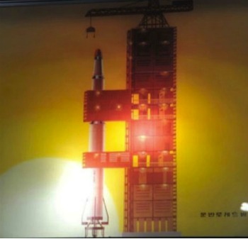
78. Search for N. Korean Rocket Continues but Yields No-Results, The Chosun Ilbo, http://englishnews@chosun.com , April 16, 2012, p. 1.
79. N. Rocket m “Could Fly 10,000 Km”, The Chosun Ilbo, http://englishnews@chosun.com , April 16, 2012, p. 1.