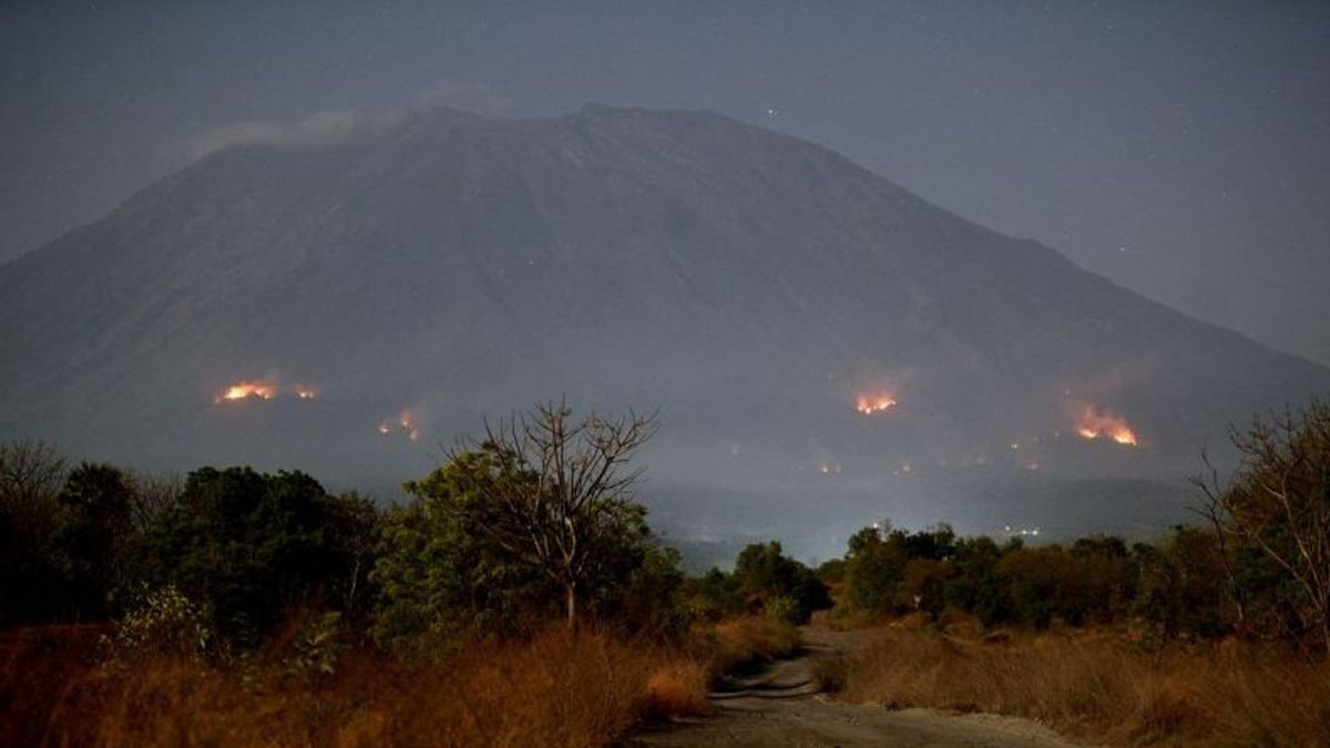


BALI - Efforts to extinguish forest and land fires (karhutla) on the slopes of Mount Agung, Bali, were hampered. The obstacle was in the form of a difficult terrain and strong winds.
"The embankment is hampered by road access to the hotspots. In addition, the location of the burning area is far above the mountain slope," said Head of the Center for Disaster Data, Information and Communication of the National Disaster Management Agency (BNPB) Abdul Muhari, in a written statement, confiscated by Antara.
Abdul explained that the fire began to spread since Thursday, September 28 to the lower, north and northwest regions.
"However, the effort to extinguish the fire is focused on the northern region, while the blackout on the northwest side is hampered by long distances and steep terrain," he added.
He said the forest and land fires at two different points were in the Kubu sub-district, Karangasem Regency.
According to him, the burned land is located on the boundary of residential land, far from residential areas.
On the evening of Thursday, September 28, some of the hotspots were controlled, but there were still hotspots in hard-to-reach areas.
Officers continued their efforts to extinguish forest and land fires on the slopes of Mount Agung on Friday, September 29.
SEE ALSO:
-
 | BERITA
Siswa Korban Perundungan di Cilacap Alami Patah Tulang Rusuk, Dirujuk ke RS Purwokerto
29 September 2023, 13:41 -
 | BERITA
Tak Lama Lagi Bakal Ada Tersangka di Kasus Dugaan Pelecehan Ajang Miss Universe Indonesia
29 September 2023, 13:44 -
 | BERITA
Kemenlu Sebut 8 WNI Korban Ledakan Tabung Gas di Taiwan Masih Dirawat di RS
29 September 2023, 13:21
Karhutla was reported to have occurred on the slopes of Mount Agung on Thursday, September 28. The fire was first reported to appear around 08.00 local time.
Information about the forest and land fires that occurred in Juntal Hamlet, Kubu Village, Kubu District, was first reported by the Village Guidance Officer (Babinsa) Kubu, who mentioned thick smoke on the slopes of the mountain.
Karhutla was also reported to have occurred in the Power Forest Management Resort area, namely in Belong Hamlet, Ban Village, Kubu District.
The Kubu Forest Management Resort on Thursday, September 28 at 20.25 WITA, informed that there was one hotspot in its area.
Meanwhile, the Power Forest Management Resort reported the presence of two hotspots in the Hamlet of Belong, Ban Village.
Forest Management, Babinsa, and Bhayangkara Personnel for Community Security and Order Development (Bhabinkamtibmas) together with members of farmer groups and local residents then tried to extinguish fires in the area.
The area of land burned in the Power Forest Management Resort is reported to be around 80 hectares. The fire includes land that is overgrown with sonokeling, acacia, dried grass, and shrubs.
Forest Management Resort officers are still investigating the cause of forest and land fires in the Kubu RPH area, which then spread to the Daya RPH area.
The English, Chinese, Japanese, Arabic, and French versions are automatically generated by the AI. So there may still be inaccuracies in translating, please always see Indonesian as our main language. (system supported by DigitalSiber.id)
Most Popular Tags
#Prabowo Subianto #NCP #Constitutional Court #Palestine #Indonesian National teamPopular


Related News