
Everybody knows the name Atlantis—the story of a civilization lost to time—sunken beneath the waves. Personally, the first thought that comes to mind when thinking of Atlantis would be an island somewhere in the Atlantic, probably now home to a couple of fish. This concept of Atlantis seems so far-fetched that it’s easy to write off as just a story. However, what if I told you our government already knows the whereabouts of Atlantis? What if it’s not as lost as we think? Well, recent scientific discoveries continue to deepen our understanding of geographic history which, in turn, helps construct an argument for the reality of Atlantis.
What was Atlantis?
Atlantis is a story as old as time itself, however, the origins are not often discussed. Though sensationalized to be this lost sunken island by cinema and works of fiction, the first Western mention of this civilization was from the renowned Greek philosopher, Plato. In his unfinished book, Timaeus, the philosopher attempted to describe the world around him and how it came to be. Since I am not fluent in ancient Greek, I will reference a translation by W.R.M. Lamb transcribed in 1925 for the account.
Written in 360 BC, the book details the travels of the wise man Solon to Egypt where he met a priestess. The priestess referenced a great civilization where her people fled after a great cataclysm. Their capital was lush with shrubbery and organized by three circles of land that surrounded two circles of water (Plato, 1925). To the north lay a great range of mountains and a southern-flowing river that ran through, or just above the city. However, the priestess described that 9,000 years prior, the city was swallowed by the sea.
Now, the sheer age of this writing opens the gates to translation errors and misunderstanding. Specifically, two quotes (referenced as Exhibit A and Exhibit B) show just how this could happen (Plato, 1925).
Exhibit A
“Now in this [island] of Atlantis there existed a confederation of kings…, which held sway over all the [island], and over many other islands also and parts of the continent; and, moreover, [25b] of the lands here within the Straits they ruled over Libya as far as Egypt, and over Europe as far as Tuscany.”
The word island is translated back to the ancient Greek word nêsos, meaning island, peninsula, coastal land, or simply a land surrounded by lakes. The description of the capital alluded to a city of circles made of land and water, with a ratio of 3:2. Theoretically, a circle of land surrounded by a circle of water would constitute an island with this ancient definition. Additionally, the fact Atlantis had such an influence across Africa and Europe could discredit the idea that it was floating somewhere in the middle of the Atlantic.
Exhibit B
“…one grievous day and night befell them, when the whole body of your warriors was swallowed up by the earth, and the [island] of Atlantis in like manner was swallowed up by the sea and vanished; wherefore also the ocean at that spot has now become impassable and unsearchable, being blocked up by the shoal mud which the island created as it settled down.”
It is interesting to note the idea that the site of Atlantis’ watery grave was impassable and blocked by mud. I believe this alone proves that there is no way it could be a lost island in the ocean. Obviously, mud does not exist in the middle of the ocean and, if it did, a ship would certainly be able to pass it. Instead of sinking, maybe the city was covered up and its access to the ocean was blocked by mud and sediment carried by a flood.
With these two quotes in mind, where could Atlantis have been?
Physical Resemblance
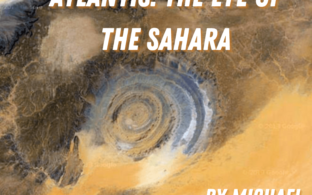
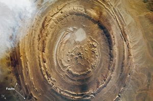
Out in the country of Mauritania, located in the western region of the Sahara, an ominous structure has drawn the attention of historians, archeologists, and even astronauts. This site is known as the Richat Structure, more commonly known as The Eye of the Sahara. NASA satellites (Figure 1) have mapped the crater-like area to be 25 miles in diameter, a similar size to the metropolitan area of Paris (Meado, 2011). The rings of the structure are eerily similar to the described structure of the capital of Atlantis, following the 3/2 ring ratio. Due to this, it is theorized that the Richat Structure is what remains of the lost civilization of Atlantis.
You might be wondering, is this a joke? The Sahara is, unsurprisingly, a desert which would make the theory of a flood rather silly. However, when taking into account our generation’s favorite issue, climate change, the idea of the Richat Structure being the graveyard of Atlantis is an actual possibility.
Geological History
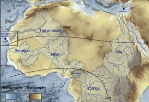
Interestingly enough, the Sahara wasn’t always a desert. Though humanity has speculated this in the Qur’an far before climate researchers used ‘science’ to prove this, the Smithsonian estimated that it was a fairly tropical region prior to 11,000 years ago (Boissoneault, 2017). Additionally, topographical and gravitational studies conducted in the Sahara uncovered a vast network of rivers and lakes, lost to climate change. For example, the rivers Senegal and Niger had vast river basins that could give credence to the idea of a green Sahara (Klokocnik, 2017). Most interestingly, researchers found in their data evidence of a river far larger, named the Tamanrasset. Much like the Nile, the magnitude of this river would easily sustain a community capable of agriculture, transportation, and trade. This river is said to start from the Atlas mountains, flowing south towards the Richat Structure before turning west and depositing into the Atlantic (Figure 2). Though there is no evidence of this river on the surface of the desert, the location mentioned in Timaeus regarding the capital would line up considering the lost river.
Knowing this, you might question how this place, in the middle of Africa, could flood. The reality is the world around us is quite unpredictable. For example, The National Science Foundation describes that between 50-100 million years ago, there was a waterway that ran south from the Mediterranean, through the Sahara, connecting to the Atlantic (NSF, 2019). Known as the Trans-Saharan seaway, it is important to note that even though this event far proceeds the demise of Atlantis, a massive amount of water is surely capable of traversing northern Africa.
What Happened?
As previously mentioned, the sea destroyed Atlantis 9,000 years prior to Solon’s visit outlined through a 2,500-year-old book. If these accounts were accurate, this would have occurred roughly 11,500 years ago. Now, the only way for water to rush in and over the region of the Richat Structure would logically be a rapid rise in sea level. How could this happen?
It is commonly believed among climate scientists that the Earth has undergone a series of Ice Ages. More often than not, the ice is said to gradually build up before rapidly melting away, causing a drastic rise in sea level. The most recent Ice Age was speculated to end 11,500 years ago where, “temperatures locally spiked as much as 20°F (11°C) within just several years” (Eldredge, 2021). Though the decline of the Ice Age was obviously gradual as opposed to an overnight event, the similarities the timelines share are intriguing. If you subscribe to the theory of climate change, then it would be a no-brainer that the melting of ice sheets would cause a massive rise of the Mediterranean Sea, causing a flood of pre-Saharan Africa and burying the city. Today, we see numerous deposits of salt along the Sahara that were carried by these waves.
Before adding one last pseudo-scientific piece of evidence to this argument it is important to note a quote from the great Travis Scott, “Seeing is believing”. I would largely agree with that sentiment. If there was such an event that happened, I would expect some sort of evidence I could physically see instead of relying on some old man’s book. However, using NASA’s WorldView imagery over the Sahara, you could make out striations that are consistent with erosions that cut across the region (Figure 3). These erosion patterns are also consistent with the topographical map of the Sahara, following the regions with the lowest elevation.

Fun Fact
Everyone’s favorite and most trusted government agency, the CIA, was also interested in the Richat structure. Through the Freedom of Information Act, files from 1965 were released that outlined a plan for the Navy to conduct a scientific flyover of the Richat Structure and 11 other sites around the world. Though they were looking for geomagnetic anomalies, the findings of this study remain redacted. What could this mean? Does the CIA know the true origins of Atlantis? What could they be hiding from us?
References
Boissoneault, L. (2017, March 24). What really turned the Sahara Desert from a green oasis into a wasteland? Smithsonian.com. Retrieved January 19, 2023, from https://www.smithsonianmag.com/science-nature/what-really-turned-sahara-desert-green-oasis-wasteland-180962668/
CIA, O. E. G. (1967). Central Intelligence Agency – CIA. CIA FOIA. Retrieved January 19, 2023, from https://www.cia.gov/readingroom/docs/CIA-RDP79B01709A000500030003-2.pdf
Eldredge, S., & Biek, B. (2021, September 16). Glad you asked: Ice ages – what are they and what causes them? Utah Geological Survey. Retrieved January 19, 2023, from https://geology.utah.gov/map-pub/survey-notes/glad-you-asked/ice-ages-what-are-they-and-what-causes-them
Klokocnik, J. (2017). Astronomický ústav av ČR – úvodní stránka. Arab Geosci. Retrieved January 19, 2023, from https://www.asu.cas.cz/~jklokocn/AJG_2017_Sahara.pdf
Meado, A. (2011). Richat Structure. NASA. Retrieved January 19, 2023, from https://earthobservatory.nasa.gov/images/92071/richat-structure
NSF, N. S. F. (2019). Ancient saharan Seaway illustrates how Earth’s climate and creatures can undergo extreme change. NSF. Retrieved January 19, 2023, from https://beta.nsf.gov/news/ancient-saharan-seaway-illustrates-how-earths
Plato, P. (1925). Plato, Timaeus. Plato, Timaeus, page 25. Retrieved January 19, 2023, from http://www.perseus.tufts.edu/hopper/text?doc=Perseus%3Atext%3A1999.01.0180%3Atext%3DTim.%3Apage%3D25